Latah/Hangman | |
|---|---|
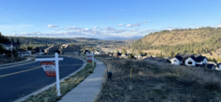
 Latah Valley from Eagle Ridge | |
 Location within the city of Spokane | |
| Coordinates: 47°37′10.0″N 117°25′58.3″W / 47.619444°N 117.432861°W | |
| Country | United States |
| State | Washington |
| County | Spokane |
| City | Spokane |
| Population (2017[1]) | |
| • Total | 4,938 |
| Demographics 2017[1] | |
| • White | 92.2% |
| • Latinx | 4% |
| • Asian/Native Hawaiian/Pacific Islander | 2.1% |
| • Black | 1.1% |
| • American Indian/Alaska Native | 0.9% |
| Time zone | UTC-8 (PST) |
| • Summer (DST) | UTC-7 (PDT) |
| ZIP Codes | 99203, 99223, 99224 |
| Area code | 509 |
Latah/Hangman is a neighborhood in Spokane, Washington.
It is named for Latah Creek, also known locally as Hangman Creek, which flows through the neighborhood and cuts the valley in which it is located.[2] Latah/Hangman is located in the valley of the creek, which isolates it somewhat from the rest of the city. It is also a very long neighborhood, stretching from the Spokane River Gorge, about a mile downstream from the city center, on the north all the way to the city's southernmost point.
Topography, dominated by the deep valley cut by the creek, along which runs U.S. Route 195, is a defining feature of the neighborhood. The creek and highway divide Latah/Hangman into numerous distinct districts including Vinegar Flats, Qualchan and Eagle Ridge. The neighborhood is known for its mixture of developed, residential areas that exist alongside undeveloped or rural areas which gives the neighborhood a more small town feel even in its northernmost limits which are just a mile from the central business district of Downtown Spokane.[3]
- ^ a b "Latah/Hangman Neighborhood Snapshot" (PDF). spokanecity.org. City of Spokane. Retrieved 20 May 2022.
- ^ Percy, Joanne. "Hangman or Latah Creek?". Spokane Historical. Eastern Washington University. Retrieved 20 May 2022.
- ^ Percy, Joanne. "Vinegar Flats - The Keller-Lorenz Vinegar Works". spokanehistorical.org. Eastern Washington University. Retrieved 21 May 2022.