Laton | |
|---|---|
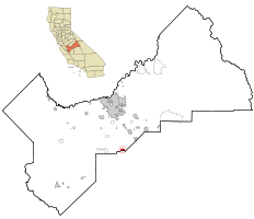
 Location in Fresno County and the state of California | |
| Coordinates: 36°26′00″N 119°41′12″W / 36.43333°N 119.68667°W | |
| Country | |
| State | |
| County | Fresno |
| Government | |
| • State Senator | Shannon Grove (R)[1] |
| • State Assembly | Joaquin Arambula (D)[2] |
| • U. S. Congress | Jim Costa (D)[3] |
| Area | |
| • Total | 1.937 sq mi (5.017 km2) |
| • Land | 1.937 sq mi (5.017 km2) |
| • Water | 0 sq mi (0 km2) 0% |
| Elevation | 259 ft (79 m) |
| Population (2020) | |
| • Total | 1,967 |
| • Density | 941/sq mi (247/km2) |
| Time zone | UTC-8 (PST) |
| • Summer (DST) | UTC-7 (PDT) |
| ZIP code | 93242 |
| Area code | 559 |
| FIPS code | 06-40746 |
| GNIS feature IDs | 1660899, 2408585 |
Laton /ˈleɪtən/ is a census-designated place (CDP) in Fresno County, California, United States. The population was 1,824 at the 2010 census, up from 1,236 at the 2000 census. Laton is located 23 miles (37 km) south-southeast of Fresno,[6] at an elevation of 259 feet (79 m).[5]
- ^ "Senators". State of California. Retrieved April 6, 2013.
- ^ "Members Assembly". State of California. Retrieved April 6, 2013.
- ^ "California's 21st Congressional District - Representatives & District Map". Civic Impulse, LLC. Retrieved April 6, 2013.
- ^ "2010 Census U.S. Gazetteer Files – Places – California". United States Census Bureau.
- ^ a b "Laton". Geographic Names Information System. United States Geological Survey, United States Department of the Interior.
- ^ Durham, David L. (1998). California's Geographic Names: A Gazetteer of Historic and Modern Names of the State. Clovis, Calif.: Word Dancer Press. p. 1060. ISBN 1-884995-14-4.
