Lauf an der Pegnitz | |
|---|---|
 Old town hall and the market square | |
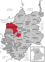
Location of Lauf an der Pegnitz within Nürnberger Land district  | |
| Coordinates: 49°30′37″N 11°16′38″E / 49.51028°N 11.27722°E | |
| Country | Germany |
| State | Bavaria |
| Admin. region | Mittelfranken |
| District | Nürnberger Land |
| Subdivisions | 29 Stadtteile |
| Government | |
| • Mayor (2020–26) | Thomas Lang[1] (FW) |
| Area | |
| • Total | 59.80 km2 (23.09 sq mi) |
| Elevation | 327 m (1,073 ft) |
| Population (2023-12-31)[2] | |
| • Total | 26,413 |
| • Density | 440/km2 (1,100/sq mi) |
| Time zone | UTC+01:00 (CET) |
| • Summer (DST) | UTC+02:00 (CEST) |
| Postal codes | 91207 |
| Dialling codes | 09123 (09126) |
| Vehicle registration | LAU, ESB, HEB, N, PEG |
| Website | www.lauf.de |
Lauf an der Pegnitz (German pronunciation: [ˈlaʊf ʔan deːɐ̯ ˈpeːɡnɪts] ; Northern Bavarian: Lauf an da Pegnitz) is a town east of Nuremberg, Germany. It is the capital of the Nürnberger Land district in Bavaria. It is in the Pegnitz river valley, which flows through the town.
In 2009, the municipality developed a climate protection plan which was supported by the German Ministry for the Environment.[3]
- ^ Liste der ersten Bürgermeister/Oberbürgermeister in kreisangehörigen Gemeinden, Bayerisches Landesamt für Statistik, 15 July 2021.
- ^ Genesis Online-Datenbank des Bayerischen Landesamtes für Statistik Tabelle 12411-003r Fortschreibung des Bevölkerungsstandes: Gemeinden, Stichtag (Einwohnerzahlen auf Grundlage des Zensus 2011).
- ^ "Startseite - Stadt Lauf a.d. Pegnitz".


