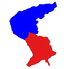
Laukkaing Township
လောက်ကိုင်မြို့နယ် | |
|---|---|
 Location in Laukkaing district (Kokang SAZ) | |
| Coordinates: 23°41′00″N 98°45′00″E / 23.68333°N 98.75000°E | |
| Country | |
| State | Shan State |
| Self-administered zone | Kokang |
| Capital | Laukkai |
| Area | |
• Total | 316.96 sq mi (820.92 km2) |
| Elevation | 3,100 ft (900 m) |
| Highest elevation | 8,317 ft (2,535 m) |
| Population (2019)[1] | |
• Total | 75,555 |
| • Density | 240/sq mi (92/km2) |
| • Ethnicities | |
| Time zone | UTC+6.30 (MMT) |
Laukkaing Township or Laukkai Township (Burmese: လောက်ကိုင်မြို့နယ်, Chinese: 老街区) is a township located within Laukkaing District, Shan State, Myanmar. It is the principal township of the Kokang Self-Administered Zone. The principal town is Laukkai (Burmese: လောက်ကိုင်မြို့). The township is divided into 137 villages organized into 8 village tracts and 2 towns, each with 3 urban wards. Besides Laukkai, the other town is Chinshwehaw in the southeast of the township.[1]
- ^ a b c Myanmar Information Management Unit (September 2019). Laukkaing Myone Daethasaingyarachatlatmya လောက်ကိုင်မြို့နယ် ဒေသဆိုင်ရာအချက်လက်များ [Laukkaing Township Regional Information] (PDF) (Report). MIMU. Retrieved 18 November 2023.
