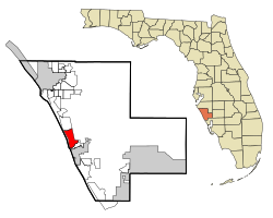
Laurel, Florida | |
|---|---|
 Location in Sarasota County and the state of Florida | |
| Coordinates: 27°8′29″N 82°27′44″W / 27.14139°N 82.46222°W[1] | |
| Country | |
| State | |
| County | Sarasota |
| Area | |
• Total | 10.18 sq mi (26.38 km2) |
| • Land | 9.08 sq mi (23.52 km2) |
| • Water | 1.10 sq mi (2.86 km2) |
| Elevation | 10 ft (3 m) |
| Population (2020) | |
• Total | 12,186 |
| • Density | 1,341.92/sq mi (518.13/km2) |
| Time zone | UTC-5 (Eastern (EST)) |
| • Summer (DST) | UTC-4 (EDT) |
| ZIP code | 34272 |
| Area code | 941 |
| FIPS code | 12-39600[3] |
| GNIS feature ID | 0285395[4] |
Laurel is a census-designated place (CDP) in Sarasota County, Florida, United States. The population was 12,186 as of 2020 census, up from 8,171 at the 2010 census. Laurel is part of the North Port–Bradenton–Sarasota, Florida Metropolitan Statistical Area.
- ^ "US Gazetteer files: 2010, 2000, and 1990". United States Census Bureau. February 12, 2011. Retrieved April 23, 2011.
- ^ "2020 U.S. Gazetteer Files". United States Census Bureau. Retrieved October 31, 2021.
- ^ "U.S. Census website". United States Census Bureau. Retrieved January 31, 2008.
- ^ "US Board on Geographic Names". United States Geological Survey. October 25, 2007. Retrieved January 31, 2008.