Laurel, Montana | |
|---|---|
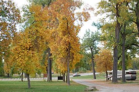
 Riverside Park along the Nez Perce National Historic Trail. | |
 Location of Laurel, Montana | |
| Coordinates: 45°40′09″N 108°46′18″W / 45.66917°N 108.77167°W | |
| Country | United States |
| State | Montana |
| County | Yellowstone |
| Settled | 1879 |
| Incorporated | October 10, 1908 |
| Government | |
| • Type | Mayor – Alderman |
| • Mayor | Dave Waggoner |
| • City Attorney | Michele L. Braukmann |
| • Police Chief | Stan Langve |
| • Fire Chief | Brent Peters |
| • City Planner | Vacant |
| Area | |
| • City | 2.607 sq mi (6.752 km2) |
| • Land | 2.605 sq mi (6.746 km2) |
| • Water | 0.002 sq mi (0.004 km2) |
| Elevation | 3,301 ft (1,006 m) |
| Population | |
| • City | 7,222 |
| • Estimate (2022)[4] | 7,203 |
| • Density | 3,310/sq mi (1,279/km2) |
| • Urban | 8,789 |
| • Urban density | 1,481/sq mi (571.8/km2) |
| • Metro | 190,208 |
| • Metro density | 29.4/sq mi (11.34/km2) |
| Time zone | UTC–7 (Mountain (MST)) |
| • Summer (DST) | UTC–6 (MDT) |
| ZIP Code | 59044 |
| Area code | 406 |
| FIPS code | 30-42700 |
| GNIS feature ID | 0773254[2] |
| Website | cityoflaurelmontana.com |
Laurel is a city in Yellowstone County, Montana, United States. It is the third largest community in the Billings Metropolitan Statistical Area, and is located in the Yellowstone Valley, as an east–west terminal division point of the BNSF Railway. The population was 7,222 at the 2020 census.[3]
Laurel is home to a Cenex Harvest States oil refinery and BNSF's Laurel Yard, the largest rail yard between St. Paul, Minnesota and Pasco, Washington.
- ^ "2023 U.S. Gazetteer Files". United States Census Bureau. Retrieved February 29, 2024.
- ^ a b U.S. Geological Survey Geographic Names Information System: Laurel, Montana
- ^ a b "Explore Census Data". United States Census Bureau. Retrieved March 1, 2024.
- ^ Cite error: The named reference
USCensusEst2022was invoked but never defined (see the help page).
