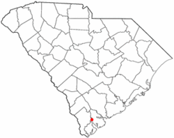
Laurel Bay, South Carolina | |
|---|---|
 Location of Laurel Bay, South Carolina | |
| Coordinates: 32°27′28″N 80°47′26″W / 32.45778°N 80.79056°W | |
| Country | United States |
| State | South Carolina |
| County | Beaufort |
| Area | |
| • Total | 5.05 sq mi (13.09 km2) |
| • Land | 4.16 sq mi (10.79 km2) |
| • Water | 0.89 sq mi (2.30 km2) |
| Elevation | 36 ft (11 m) |
| Population | |
| • Total | 5,082 |
| • Density | 1,220.46/sq mi (471.19/km2) |
| Time zone | UTC-5 (Eastern (EST)) |
| • Summer (DST) | UTC-4 (EDT) |
| ZIP code | 29906 |
| Area code(s) | 843, 854 |
| FIPS code | 45-40525[3] |
| GNIS feature ID | 1227789[4] |
Laurel Bay is a census-designated place and military housing complex in Beaufort County, South Carolina, United States. The population was 5,891 at the 2010 census.[5] As defined by the U.S. Census Bureau, Laurel Bay is included within the Hilton Head Island-Bluffton-Beaufort, SC Metropolitan Statistical Area.
The base primarily houses military personnel with families that are stationed at the nearby military bases: MCAS Beaufort, MCRD Parris Island, and USNH Beaufort. The housing area first opened in the mid-1950s.
- ^ "ArcGIS REST Services Directory". United States Census Bureau. Retrieved October 15, 2022.
- ^ "Census Population API". United States Census Bureau. Retrieved October 15, 2022.
- ^ "U.S. Census website". United States Census Bureau. Retrieved January 31, 2008.
- ^ "US Board on Geographic Names". United States Geological Survey. October 25, 2007. Retrieved January 31, 2008.
- ^ "Profile of General Population and Housing Characteristics: 2010 Demographic Profile Data (DP-1): Laurel Bay CDP, South Carolina". United States Census Bureau. Retrieved November 24, 2011.