Laurel County | |
|---|---|
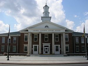
 Laurel County courthouse in London | |
 Location within the U.S. state of Kentucky | |
 Kentucky's location within the U.S. | |
| Coordinates: 37°06′38″N 84°07′04″W / 37.11067°N 84.1178°W | |
| Country | |
| State | |
| Founded | December 21, 1825 |
| Named for | Mountain laurel trees |
| Seat | London |
| Largest city | London |
| Area | |
• Total | 444 sq mi (1,150 km2) |
| • Land | 434 sq mi (1,120 km2) |
| • Water | 9.7 sq mi (25 km2) 2.2% |
| Population (2020) | |
• Total | 62,613 |
• Estimate (2023) | 63,296 |
| • Density | 140/sq mi (54/km2) |
| Time zone | UTC−5 (Eastern) |
| • Summer (DST) | UTC−4 (EDT) |
| Congressional district | 5th |
| Website | londonky |
Laurel County is a county located in the southeastern portion of the U.S. state of Kentucky. As of the 2020 census, the population was 62,613.[1] Its county seat is London.[2] After a special election in January 2016 alcohol sales are permitted only in the city limits of London. The ordinance went into effect on March 27, 2016, 60 days after results of the election. Laurel County is included in the London, KY Micropolitan Statistical Area.
- ^ "State & County QuickFacts". United States Census Bureau. Retrieved June 30, 2022.
- ^ "Find a County". National Association of Counties. Retrieved June 7, 2011.