| Laurel Highlands Hiking Trail | |
|---|---|
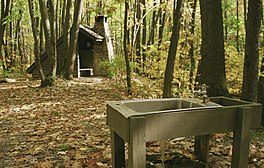
 A backpacking shelter along the Laurel Highlands Hiking Trail | |
| Length | 70.1 mi (112.8 km) |
| Location | Fayette County, Somerset County, Westmoreland County, and Cambria County, Pennsylvania, US |
| Trailheads | Ohiopyle State Park Pennsylvania Route 56 |
| Use | Hiking |
| Highest point | High |
| Difficulty | Moderate to strenuous |
| Season | Year-round |
| Hazards | Uneven and wet terrain, rattlesnakes, mosquitoes, ticks, black bears |
| Trail map | |
 | |
The Laurel Highlands Hiking Trail is a 70.1-mile (112.8 km) hiking trail in southwestern Pennsylvania, which largely follows the Laurel Hill geologic formation. It begins at Ohiopyle State Park and travels generally to the northeast, and ends at Conemaugh Gorge near Johnstown. Construction of the trail began in 1970. It has been named as one of Pennsylvania's most popular backpacking trails and the premier trail in the southwestern region of the state.[1]
Except for climbs out of river valleys at its southwestern and northeastern ends, the trail is relatively level and appropriate for winter uses such as cross-country skiing and snowshoeing.[2] The trail travels through Fayette, Somerset, Westmoreland, and Cambria Counties, usually alongside county lines that follow the ridgetops.[3] Some of the trail is within the boundaries of various discontiguous tracts of Laurel Ridge State Park. It also traverses several other nearby state parks, plus tracts of Forbes State Forest, various Pennsylvania State Game Lands, and a few tracts of private property.[1] The trail is marked with yellow blazes, and several connecting trails to parking or shelters are marked with blue blazes. Parking lots at highway crossings serve as intermediate trailheads and some have drinking water.[3]
Uniquely among long-distance trails in Pennsylvania, the Laurel Highlands Hiking Trail is protected as a linear state park, with management and maintenance coordinated by Laurel Ridge State Park. The trail is also a component of the Potomac Heritage National Scenic Trail, and is the only off-road component of that trail.[4]
- ^ a b Mitchell, Jeff (2005). Backpacking Pennsylvania: 37 Great Hikes. Mechanicsburg, Pennsylvania: Stackpole Books. p. 208. ISBN 0811731804.
- ^ Cramer, Ben, ed. (2008). Pennsylvania Hiking Trails (13th ed.). Mechanicsburg, Pennsylvania: Stackpole Books. p. 94. ISBN 9780811734776.
- ^ a b "Laurel Ridge State Park". Pennsylvania Department of Conservation and Natural Resources. Archived from the original on October 9, 2011. Retrieved December 2, 2006.
- ^ Pennsylvania Department of Conservation and Natural Resources. "Laurel Ridge and the Laurel Highlands Hiking Trail" (PDF). elibrary.dcnr.pa.gov. Retrieved October 29, 2023.