Lauzerte | |
|---|---|
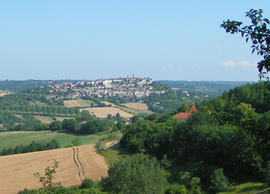
 A general view of Lauzerte | |
| Coordinates: 44°15′24″N 1°08′18″E / 44.2567°N 1.1383°E | |
| Country | France |
| Region | Occitania |
| Department | Tarn-et-Garonne |
| Arrondissement | Castelsarrasin |
| Canton | Pays de Serres Sud-Quercy |
| Government | |
| • Mayor (2020–2026) | François-Thierry Le Moing[1] |
| Area 1 | 44.56 km2 (17.20 sq mi) |
| Population (2021)[2] | 1,448 |
| • Density | 32/km2 (84/sq mi) |
| Time zone | UTC+01:00 (CET) |
| • Summer (DST) | UTC+02:00 (CEST) |
| INSEE/Postal code | 82094 /82110 |
| Elevation | 98–270 m (322–886 ft) (avg. 176 m or 577 ft) |
| 1 French Land Register data, which excludes lakes, ponds, glaciers > 1 km2 (0.386 sq mi or 247 acres) and river estuaries. | |
Lauzerte (French pronunciation: [lozɛʁt]; Languedocien: Lausèrta) is a commune in the Tarn-et-Garonne department in the Occitanie region in southern France. It is a member of Les Plus Beaux Villages de France (The Most Beautiful Villages of France) Association.
Etymology of the name: Two interpretations include the possible Latin root of “Villaserta” and more likely, the Gallic root, “lauzes”, flat stones used as paving or roofing, and “erta” from the local Occitan dialect, meaning hill, thus Hill of Stones. The fact that the barbican was exploited as a quarry supports this derivation.
A medieval bastide perched above the valleys and hills of the area known as the Quercy Blanc, Lauzerte is one of the Most Beautiful Villages of France, a distinction granted to only 155 villages in the country. Founded in the 12th century by the Count of Toulouse, the village is located on the routes of the Santiago de Compostella.
- ^ "Répertoire national des élus: les maires" (in French). data.gouv.fr, Plateforme ouverte des données publiques françaises. 13 September 2022.
- ^ "Populations légales 2021" (in French). The National Institute of Statistics and Economic Studies. 28 December 2023.


