Lavangen Municipality
Lavangen kommune Loabága suohkan | |
|---|---|
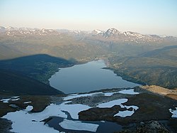
 View of Inner Lavangen | |
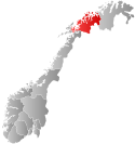
 Troms within Norway | |
 Lavangen within Troms | |
| Coordinates: 68°39′28″N 17°35′01″E / 68.65778°N 17.58361°E | |
| Country | Norway |
| County | Troms |
| District | Midt-Troms |
| Established | 1 January 1907 |
| • Preceded by | Ibestad Municipality |
| Disestablished | 1 January 1964 |
| • Succeeded by | Salangen Municipality |
| Re-established | 1 January 1977 |
| • Preceded by | Salangen Municipality |
| Administrative centre | Tennevoll |
| Government | |
| • Mayor (2019) | Hege Beathe Myrseth Rollmoen (Sp) |
| Area | |
| • Total | 301.62 km2 (116.46 sq mi) |
| • Land | 296.07 km2 (114.31 sq mi) |
| • Water | 5.55 km2 (2.14 sq mi) 1.8% |
| • Rank | #266 in Norway |
| Highest elevation | 1,457.49 m (4,781.79 ft) |
| Population (2024) | |
| • Total | 986 |
| • Rank | #335 in Norway |
| • Density | 3.3/km2 (9/sq mi) |
| • Change (10 years) | |
| Demonym | Lavangsværing[2] |
| Official language | |
| • Norwegian form | Neutral |
| Time zone | UTC+01:00 (CET) |
| • Summer (DST) | UTC+02:00 (CEST) |
| ISO 3166 code | NO-5518[4] |
| Website | Official website |
Lavangen (Norwegian) or Loabák (Northern Sami)[5] is a municipality in Troms county, Norway. The administrative centre of the municipality is the village of Tennevoll. Other villages in Lavangen include Fossbakken and Spansdalen (in the inland areas) and Kjeiprød, Røkenes, Låternes, Tennevoll, Hesjevika, Soløy, and Å (surrounding the fjord).
The 302-square-kilometre (117 sq mi) municipality is the 266th largest by area out of the 357 municipalities in Norway. Lavangen is the 335th most populous municipality in Norway with a population of 986. The municipality's population density is 3.3 inhabitants per square kilometre (8.5/sq mi) and its population has decreased by 2.8% over the previous 10-year period.[6][7]
- ^ "Høgaste fjelltopp i kvar kommune" (in Norwegian). Kartverket. 16 January 2024.
- ^ "Navn på steder og personer: Innbyggjarnamn" (in Norwegian). Språkrådet.
- ^ "Forskrift om målvedtak i kommunar og fylkeskommunar" (in Norwegian). Lovdata.no.
- ^ Bolstad, Erik; Thorsnæs, Geir, eds. (26 January 2023). "Kommunenummer". Store norske leksikon (in Norwegian). Kunnskapsforlaget.
- ^ Cite error: The named reference
sami namewas invoked but never defined (see the help page). - ^ Statistisk sentralbyrå. "Table: 06913: Population 1 January and population changes during the calendar year (M)" (in Norwegian).
- ^ Statistisk sentralbyrå. "09280: Area of land and fresh water (km²) (M)" (in Norwegian).

