43°06′37″N 088°02′04″W / 43.11028°N 88.03444°W
Lawrence J. Timmerman Airport | |||||||||||||||||||||||
|---|---|---|---|---|---|---|---|---|---|---|---|---|---|---|---|---|---|---|---|---|---|---|---|
 | |||||||||||||||||||||||
| Summary | |||||||||||||||||||||||
| Airport type | Public | ||||||||||||||||||||||
| Owner | Milwaukee County | ||||||||||||||||||||||
| Serves | Milwaukee, Wisconsin | ||||||||||||||||||||||
| Time zone | CST (UTC−06:00) | ||||||||||||||||||||||
| • Summer (DST) | CDT (UTC−05:00) | ||||||||||||||||||||||
| Elevation AMSL | 745 ft / 227 m | ||||||||||||||||||||||
| Website | timmermanairport | ||||||||||||||||||||||
| Maps | |||||||||||||||||||||||
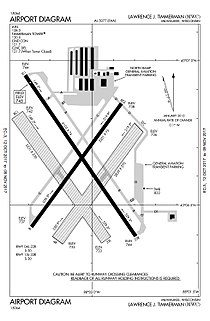
 FAA airport diagram | |||||||||||||||||||||||
 | |||||||||||||||||||||||
| Runways | |||||||||||||||||||||||
| |||||||||||||||||||||||
| Statistics | |||||||||||||||||||||||
| |||||||||||||||||||||||
Lawrence J. Timmerman Airport (IATA: MWC, ICAO: KMWC, FAA LID: MWC), known locally as Timmerman Field, is an airport in Milwaukee, Wisconsin, United States, owned by Milwaukee County. Located 5 miles (8 km) northwest of the city center, it is used mainly for general or private aviation.[1] It is included in the Federal Aviation Administration (FAA) National Plan of Integrated Airport Systems for 2025–2029, in which it is categorized as a regional reliever airport facility.[2]
- ^ a b FAA Airport Form 5010 for MWC PDF, effective August 8, 2024.
- ^ "NPIAS Report 2025-2029 Appendix A" (PDF). Federal Aviation Administration. October 28, 2024. Retrieved November 11, 2024.

