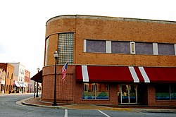
Lawrenceville, Virginia | |
|---|---|
 Lawrenceville | |
 Location of Lawrenceville, Virginia | |
| Coordinates: 36°45′30″N 77°51′2″W / 36.75833°N 77.85056°W | |
| Country | United States |
| State | Virginia |
| County | Brunswick |
| Area | |
• Total | 1.15 sq mi (2.98 km2) |
| • Land | 1.15 sq mi (2.98 km2) |
| • Water | 0.00 sq mi (0.00 km2) |
| Elevation | 266 ft (81 m) |
| Population (2020) | |
• Total | 1,014 |
• Estimate () | 1 |
| • Density | 880/sq mi (340/km2) |
| Time zone | UTC−5 (Eastern (EST)) |
| • Summer (DST) | UTC−4 (EDT) |
| ZIP code | 23868 |
| Area code | 434 |
| FIPS code | 51-44520[2] |
| GNIS feature ID | 1498503[3] |
| Website | lawrencevilleweb |
Lawrenceville is a town in Brunswick County, Virginia, United States. Per the 2020 census, the population was 1,014.[4] Located by the Meherrin River, it is the county seat of Brunswick County.[5] In colonial times, Lieutenant Governor Alexander Spotswood had a stockade built nearby, called Fort Christanna, where converted Native American allies were housed and educated.
Saint Paul's College, a historically black college affiliated with the Episcopal Church, was founded here in 1888. It operated until 2013.
Lumber, tobacco, livestock, and other farm products are grown in the area. In a county along the southern border of the state, the town is near the northernmost area for cotton growing.
- ^ "2019 U.S. Gazetteer Files". United States Census Bureau. Retrieved August 7, 2020.
- ^ "U.S. Census website". United States Census Bureau. Retrieved January 31, 2008.
- ^ "US Board on Geographic Names". United States Geological Survey. October 25, 2007. Retrieved January 31, 2008.
- ^ "Lawrenceville town, Virginia". United States Census Bureau. Retrieved December 25, 2022.
- ^ "Find a County". National Association of Counties. Retrieved June 7, 2011.