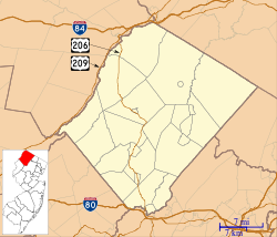
Layton, New Jersey | |
|---|---|
 Layton along County Route 560. | |
| Coordinates: 41°12′58″N 74°49′23″W / 41.21611°N 74.82306°W | |
| Country | |
| State | |
| County | Sussex |
| Township | Sandyston |
| Named for | John Layton |
| Area | |
| • Total | 6.99 sq mi (18.11 km2) |
| • Land | 6.98 sq mi (18.07 km2) |
| • Water | 0.02 sq mi (0.04 km2) |
| Elevation | 574 ft (175 m) |
| Population | |
| • Total | 692 |
| • Density | 99.18/sq mi (38.29/km2) |
| ZIP Code | 07826 |
| FIPS code | 34-39600[3] |
| GNIS feature ID | 0877713[4] |

Layton is an unincorporated community and census-designated place (CDP)[5] located within Sandyston Township in Sussex County, in the U.S. state of New Jersey.[6] The area is served as United States Postal Service ZIP Code 07851.
As of the 2000 United States census, the population for ZIP Code Tabulation Area 07851 was 250.[7]
Layton is located 574 feet (175 m) above sea level.[4]
The Dingman's Ferry Bridge, crosses the Delaware River at Layton, connecting County Route 560 in New Jersey to PA 739 in Pennsylvania.
- ^ "ArcGIS REST Services Directory". United States Census Bureau. Retrieved October 11, 2022.
- ^ Census Data Explorer: Layton CDP, New Jersey, United States Census Bureau. Accessed June 15, 2023.
- ^ Geographic Codes Lookup for New Jersey, Missouri Census Data Center. Accessed June 9, 2023.
- ^ a b "Layton". Geographic Names Information System. United States Geological Survey, United States Department of the Interior. Retrieved September 22, 2012.
- ^ State of New Jersey Census Designated Places - BVP20 - Data as of January 1, 2020, United States Census Bureau. Accessed December 1, 2022.
- ^ Locality Search, State of New Jersey. Accessed June 9, 2016.
- ^ Census 2000 Fact Sheet for ZIP Code Tabulation Area 07851 Archived 2011-06-08 at the Wayback Machine, United States Census Bureau. Accessed September 3, 2007.


