Le Mesnil-le-Roi | |
|---|---|
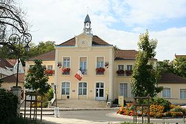
 Town hall | |
| Coordinates: 48°56′15″N 2°07′39″E / 48.9375°N 2.1275°E | |
| Country | France |
| Region | Île-de-France |
| Department | Yvelines |
| Arrondissement | Saint-Germain-en-Laye |
| Canton | Sartrouville |
| Intercommunality | CA Saint Germain Boucles Seine |
| Government | |
| • Mayor (2020–2026) | Serge Caseris[1] |
| Area 1 | 3.27 km2 (1.26 sq mi) |
| Population (2021)[2] | 6,322 |
| • Density | 1,900/km2 (5,000/sq mi) |
| Time zone | UTC+01:00 (CET) |
| • Summer (DST) | UTC+02:00 (CEST) |
| INSEE/Postal code | 78396 /78600 |
| Elevation | 20–71 m (66–233 ft) (avg. 42 m or 138 ft) |
| 1 French Land Register data, which excludes lakes, ponds, glaciers > 1 km2 (0.386 sq mi or 247 acres) and river estuaries. | |
Le Mesnil-le-Roi (French pronunciation: [lə menil lə ʁwa] ) is a commune in the Yvelines department in the Île-de-France region in north-central France. It is about 3.5 km (2 mi) from Saint-Germain-en-Laye.
The name "Mesnil" comes from Latin: mansionilis meaning "little estate". The name "Le Mesnil-le-Roi" could be said "The King's small estate" (Francis I). On the other hand, the name of Mesnil-le-Roi in the time of the French Revolution was Le Mesnil-Carrières, "Mesnil quarries".
The inhabitants are called Mesnilois (male) and Mesniloise (female).
- ^ "Répertoire national des élus: les maires" (in French). data.gouv.fr, Plateforme ouverte des données publiques françaises. 13 September 2022.
- ^ "Populations légales 2021" (in French). The National Institute of Statistics and Economic Studies. 28 December 2023.


