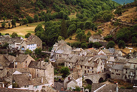
Le Pont-de-Montvert | |
|---|---|
Part of Pont-de-Montvert-Sud-Mont-Lozère | |
 View of Le Pont-de-Montvert | |
| Coordinates: 44°21′51″N 3°44′40″E / 44.3642°N 3.7444°E | |
| Country | France |
| Region | Occitania |
| Department | Lozère |
| Arrondissement | Florac |
| Canton | Saint-Étienne-du-Valdonnez |
| Commune | Pont-de-Montvert-Sud-Mont-Lozère |
Area 1 | 90.25 km2 (34.85 sq mi) |
| Population (2019)[1] | 313 |
| • Density | 3.5/km2 (9.0/sq mi) |
| Time zone | UTC+01:00 (CET) |
| • Summer (DST) | UTC+02:00 (CEST) |
| Postal code | 48220 |
| Elevation | 665–1,699 m (2,182–5,574 ft) (avg. 875 m or 2,871 ft) |
| 1 French Land Register data, which excludes lakes, ponds, glaciers > 1 km2 (0.386 sq mi or 247 acres) and river estuaries. | |
Le Pont-de-Montvert (French pronunciation: [lə pɔ̃ də mɔ̃vɛʁ]; Occitan: Lo Pònt de Montverd) is a former commune in the Lozère département in southern France. On 1 January 2016, it was merged into the new commune of Pont-de-Montvert-Sud-Mont-Lozère.[2]
It is located in the heart of the Parc National des Cévennes. The inhabitants of Le Pont-de-Montvert are called Pontoises or Montvertipontains.


