| Leafield | |
|---|---|
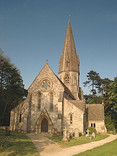
 St Michael's parish church | |
Location within Oxfordshire | |
| Population | 945 (2011 Census) |
| OS grid reference | SP318153 |
| Civil parish |
|
| District | |
| Shire county | |
| Region | |
| Country | England |
| Sovereign state | United Kingdom |
| Post town | Witney |
| Postcode district | OX29 |
| Dialling code | 01993 |
| Police | Thames Valley |
| Fire | Oxfordshire |
| Ambulance | South Central |
| UK Parliament | |
| Website | Parish Council |
Leafield is a village and civil parish about 4 miles (6.4 km) northwest of Witney in West Oxfordshire, England. The parish includes the hamlet of Langley, 1 mile (1.6 km) west of Leafield village. The 2011 Census recorded the parish's population as 945.[1] The village is 635 feet (194 m) above sea level in the Cotswold Hills. It was the highest point in Oxfordshire until the 1974 county boundary changes enlarged the county.
- ^ "Area: Leafield (Parish): Key Figures for 2011 Census: Key Statistics". Neighbourhood Statistics. Office for National Statistics. Retrieved 12 December 2014.
