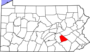
Lebanon County | |
|---|---|
 | |
 Location within the U.S. state of Pennsylvania | |
 Pennsylvania's location within the U.S. | |
| Coordinates: 40°22′N 76°28′W / 40.37°N 76.46°W | |
| Country | |
| State | |
| Founded | February 16, 1813 |
| Seat | Lebanon |
| Largest city | Lebanon |
| Area | |
• Total | 362 sq mi (940 km2) |
| • Land | 362 sq mi (940 km2) |
| • Water | 0.7 sq mi (2 km2) 0.2% |
| Population | |
• Estimate (2020) | 143,257 |
| • Density | 390/sq mi (150/km2) |
| Time zone | UTC−5 (Eastern) |
| • Summer (DST) | UTC−4 (EDT) |
| Congressional district | 9th |
| Website | www |
Lebanon County (/ˈlɛbnən/ Pennsylvania Dutch: Lebanon Kaundi) is a county in the Commonwealth of Pennsylvania, United States. As of the 2020 census, the population was 143,257.[1] Its county seat is the city of Lebanon.[2] It lies 72 miles northwest of Philadelphia, which is the nearest major city. The county is part of the South Central Pennsylvania region of the state.[a]
The county was formed from portions of Dauphin and Lancaster counties in 1813, with minor boundary revisions in 1814 and 1821.[3] Lebanon County comprises the Lebanon metropolitan statistical area, which is part of the Harrisburg–York–Lebanon combined statistical area.
- ^ "State & County QuickFacts". United States Census Bureau. Archived from the original on June 6, 2011. Retrieved November 17, 2013.
- ^ "Find a County". National Association of Counties. Archived from the original on May 31, 2011. Retrieved June 7, 2011.
- ^ Our County Archived July 9, 2013, at the Wayback Machine. Lebanon County Historical Society. Retrieved on July 23, 2013.
Cite error: There are <ref group=lower-alpha> tags or {{efn}} templates on this page, but the references will not show without a {{reflist|group=lower-alpha}} template or {{notelist}} template (see the help page).
