| Legion State Park | |
|---|---|
 | |
| Location | Louisville, Mississippi, United States |
| Coordinates | 33°09′05″N 89°02′32″W / 33.151421°N 89.042344°W[1] |
| Area | 453 acres (183 ha)[2] |
| Elevation | 453 ft (138 m) |
| Established | 1934 |
| Administered by | Mississippi Department of Wildlife, Fisheries, and Parks |
| Designation | Mississippi state park |
| Website | Official website |
Legion State Park | |
 | |
| Location | 635 Legion State Park Rd., Louisville, Mississippi |
| Area | 120 acres (49 ha) |
| Built | 1934 |
| Built by | CCC |
| Architectural style | Rustic |
| MPS | State Parks in Mississippi built by the CCC between 1934 - 1942 |
| NRHP reference No. | 98001333 |
| Added to NRHP | November 5, 1998 |
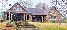
Legion State Park is public recreation area located on the north edge of the city of Louisville, Mississippi, and adjacent to Tombigbee National Forest.[3] As Legion State Park Historic District, the state park entered the National Register of Historic Places in 1998.[2] It is managed by the Mississippi Department of Wildlife, Fisheries and Parks.
