Leicestershire | |
|---|---|
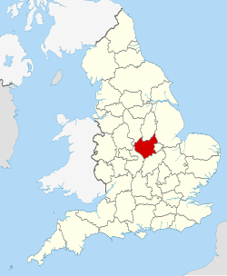
 Leicestershire within England | |
| Coordinates: 52°39′22″N 1°11′24″W / 52.656°N 1.19°W | |
| Sovereign state | United Kingdom |
| Constituent country | England |
| Region | East Midlands |
| Established | Historic |
| Time zone | UTC+0 (GMT) |
| • Summer (DST) | UTC+1 (BST) |
| UK Parliament | 10 MPs |
| Ceremonial county | |
| Lord Lieutenant | Mike Kapur |
| High Sheriff | Henrietta Chubb[1] (2023–24) |
| Area | 2,156 km2 (832 sq mi) |
| • Rank | 28th of 48 |
| Population (2022)[2] | 1,095,554 |
| • Rank | 20th of 48 |
| Density | 508/km2 (1,320/sq mi) |
| Ethnicity |
|
| Non-metropolitan county | |
| County council | Leicestershire County Council |
| Control | Conservative |
| Admin HQ | County Hall, Glenfield |
| Area | 2,083 km2 (804 sq mi) |
| • Rank | 15th of 21 |
| Population (2022)[3] | 722,155 |
| • Rank | 16th of 21 |
| Density | 347/km2 (900/sq mi) |
| ISO 3166-2 | GB-LEC |
| GSS code | E10000018 |
| ITL | TLF22 |
| Website | leicestershire |
| Districts | |
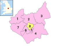
 Districts of Leicestershire Unitary County council area | |
| Districts | |
Leicestershire (/ˈlɛstərʃɪər, -ʃər/ LEST-ər-sheer, -shər) is a ceremonial county in the East Midlands of England. It is bordered by Derbyshire, Nottinghamshire, and Lincolnshire to the north, Rutland to the east, Northamptonshire to the south-east, Warwickshire to the south-west, and Staffordshire to the west. The city of Leicester is the largest settlement and the county town.
The county has an area of 2,156 km2 (832 sq mi) and a population of 712,300. Leicester occupies the centre of the county and is by far the largest settlement, with a built-up area population of 357,000. The remainder of the county is largely rural, and the next-largest settlements are Loughborough (65,000), Hinckley (50,000), and Coalville (22,000). For local government purposes Leicestershire comprises a non-metropolitan county, with seven districts, and the unitary authority area of Leicester.
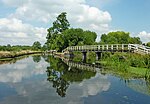
Leicestershire is generally a lowland county, characterised by small, rolling hills. It is bisected by the River Soar, which rises near the Warwickshire border south of Hinckley and flows north through Leicester and Loughborough before reaching the Trent at the county boundary. To the west of the river is Charnwood Forest, an upland area which contains Bardon Hill, which at 278 m (912 ft) is the county's highest point.
There are prehistoric earthworks in the county, and Leicester was a Roman settlement. The region was settled by the Angles in the sixth century and became part of the Kingdom of Mercia, and the county existed at the time of the Domesday Survey in the 1080s. The county has had a relatively settled existence, however it was the site of the Battle of Bosworth Field in 1485, which established the Tudor dynasty's position as monarchs of England. During the Industrial Revolution the Leicestershire coalfield in the north and west of the county was exploited. Leicester became known for shoemaking, and with Loughborough continues to be a manufacturing centre. In agriculture the county is known for Stilton cheese and Melton Mowbray pork pies.[4]
- ^ "No. 63990". The London Gazette. 9 March 2023. p. 4634.
- ^ "Mid-2022 population estimates by Lieutenancy areas (as at 1997) for England and Wales". Office for National Statistics. 24 June 2024. Retrieved 26 June 2024.
- ^ "Mid-Year Population Estimates, UK, June 2022". Office for National Statistics. 26 March 2024. Retrieved 3 May 2024.
- ^ "Leicestershire | county, England, United Kingdom | Britannica". www.britannica.com. Retrieved 29 June 2023.


