This article has multiple issues. Please help improve it or discuss these issues on the talk page. (Learn how and when to remove these messages)
|
Leidsche Rijn | |
|---|---|
Neighborhood in Utrecht | |
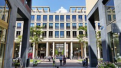
 Leidsche Rijn Centrum, the shopping centre of Leidsche Rijn | |
 | |
| Coordinates: 52°05′50″N 5°03′53″E / 52.097094°N 5.064638°E | |
| Population (2022) | |
| • Total | 95,000 |
| Time zone | UTC+1 (CET) |
| • Summer (DST) | UTC+2 (CEST) |
| Postcodes | 3454-3545 |
Leidsche Rijn (Dutch pronunciation: [ˈlɛitsə ˈrɛin], Utrecht dialect: [ˈlaitsə ˈʁain]) is a new construction site and neighborhood in Utrecht, the capital of the Dutch province of Utrecht. The area is located west of the Amsterdam–Rhine Canal and its name is derived from the Leidse Rijn canal, which runs through it. At the time of its inception in the 1990s and in the decades that followed, Leidsche Rijn was the largest Vinex location in the Netherlands. Most of this location was on the territory of the former municipality of Vleuten-De Meern, located west of the city of Utrecht. A smaller part of this location, namely the area of Hoge and Lage Weide, was located in the municipality of Utrecht.
Vleuten-De Meern was added to the municipality of Utrecht on January 1, 2001. The intended size of the Vinex location was about 30,000 houses for about 90,000 inhabitants. The Utrecht City Council decided to divide it into two districts, namely the Vleuten-De Meern district and the Leidsche Rijn district. Despite this division, the aforementioned neighborhoods are the largest in the municipality of Utrecht in terms of population with approximately 50,000 and 45,000 inhabitants, respectively.
Leidsche Rijn has multiple primary and secondary schools, such as the Leidsche Rijn College or Academie Tien.