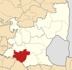
Lekwa | |
|---|---|
 Location in Mpumalanga | |
| Country | South Africa |
| Province | Mpumalanga |
| District | Gert Sibande |
| Seat | Standerton |
| Wards | 15 |
| Government | |
| • Type | Municipal council |
| Area | |
• Total | 4,585 km2 (1,770 sq mi) |
| Population (2011)[1] | |
• Total | 115,662 |
| • Density | 25/km2 (65/sq mi) |
| Racial makeup (2011) | |
| • Black African | 84.2% |
| • Coloured | 2.9% |
| • Indian/Asian | 1.2% |
| • White | 11.4% |
| First languages (2011) | |
| • Zulu | 66.2% |
| • Afrikaans | 13.2% |
| • Sotho | 10.3% |
| • English | 3.6% |
| • Other | 6.7% |
| Time zone | UTC+2 (SAST) |
| Municipal code | MP305 |
Lekwa Municipality (Zulu: UMasipala wase Lekwa; Afrikaans: Lekwa Munisipaliteit; Sotho: Masepala wa Lekwa) is a local municipality situated in the southwest of the Gert Sibande District Municipality, in the Mpumalanga province of South Africa. Standerton, an urban node, is the seat of the municipality. It was inaugurated on 5 December 2000 after the amalgamation of the Standerton, Sakhile and Morgenzon councils.[2] Agriculture, forestry and fishing constitute about 30% of its economy. It is situated on open grassland plains of the Highveld region, which is traversed by the west-flowing Vaal River, for which it is named. Lekwa is the Sesotho name for the Vaal River.[2] Lekwa's first two decades were marked by increasing maladministration, which culminated in a collapse in governance and service delivery by 2020.[3] This had negative consequences for its residents and businesses, the environment, and utilities which were not paid for their services.[4]
- ^ a b c "Statistics by place". Statistics South Africa. Retrieved 27 September 2015.
- ^ a b "Lekwa Local Municipality (MP305)". Municipalities of South Africa. 2012-2020 Yes Media. Retrieved 30 October 2020.
- ^ Zacarias, Sifiso; Thabethe, Delani. "Service delivery: Workers down tools against allegations of corruption in Lekwa Municipality". MorningLive, SABC News. youtube.com. Archived from the original on 2021-12-15. Retrieved 6 November 2020.
- ^ "When a Community has had Enough". youtube.com. Carte Blanche, M-Net. Archived from the original on 2021-05-10. Retrieved 6 November 2020.
