Lelystad | |
|---|---|
City and Municipality | |
Aerial view of the city Zuil van Lely in the city center Batavia Stad Replica of the Batavia Bataviahaven | |
|
| |
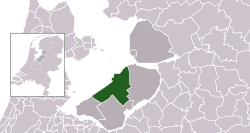
 Location in Flevoland | |
| Coordinates: 52°30′N 5°29′E / 52.500°N 5.483°E | |
| Country | |
| Province | |
| Region | Amsterdam metropolitan area |
| Established | 1 January 1967 |
| Government | |
| • Body | Municipal council |
| • Mayor | Henry Meijdam (VVD) |
| Area | |
• Total | 765.45 km2 (295.54 sq mi) |
| • Land | 230.32 km2 (88.93 sq mi) |
| • Water | 535.13 km2 (206.61 sq mi) |
| Elevation | −3 m (−10 ft) |
| Population (January 2021)[4] | |
• Total | 79,811 |
| • Density | 347/km2 (900/sq mi) |
| Time zone | UTC+1 (CET) |
| • Summer (DST) | UTC+2 (CEST) |
| Postcode | 8200–8249 |
| Area code | 0320 |
| Website | www |
Lelystad (Dutch pronunciation: [ˈleːlistɑt] ) is a Dutch municipality and the capital city of the province of Flevoland in the central Netherlands. The city, built on reclaimed land, was founded in 1967 and was named after Cornelis Lely, who engineered the Afsluitdijk that made the reclamation possible. Lelystad is situated approximately three metres (10 feet) below sea level.
- ^ "Portefeuilleverdeling" [Tasks] (in Dutch). Gemeente Lelystad. Archived from the original on 10 September 2013. Retrieved 1 September 2013.
- ^ "Kerncijfers wijken en buurten 2020" [Key figures for neighbourhoods 2020]. StatLine (in Dutch). CBS. 24 July 2020. Retrieved 19 September 2020.
- ^ "Postcodetool for 8232ZX". Actueel Hoogtebestand Nederland (in Dutch). Het Waterschapshuis. Archived from the original on 21 September 2013. Retrieved 1 September 2013.
- ^ "Bevolkingsontwikkeling; regio per maand" [Population growth; regions per month]. CBS Statline (in Dutch). CBS. 1 January 2021. Retrieved 2 January 2022.


