Lenggries | |
|---|---|
 | |
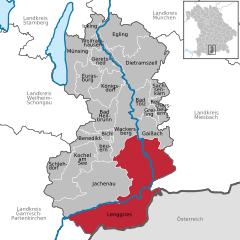
Location of Lenggries within Bad Tölz-Wolfratshausen district  | |
| Coordinates: 47°40′49″N 11°34′26″E / 47.68028°N 11.57389°E | |
| Country | Germany |
| State | Bavaria |
| Admin. region | Oberbayern |
| District | Bad Tölz-Wolfratshausen |
| Subdivisions | 7 Ortsteile |
| Government | |
| • Mayor (2020–26) | Stefan Klaffenbacher[1] (FW) |
| Area | |
• Total | 242.90 km2 (93.78 sq mi) |
| Elevation | 679 m (2,228 ft) |
| Population (2023-12-31)[2] | |
• Total | 10,143 |
| • Density | 42/km2 (110/sq mi) |
| Time zone | UTC+01:00 (CET) |
| • Summer (DST) | UTC+02:00 (CEST) |
| Postal codes | 83661 |
| Dialling codes | 08042, 08045 (Fall) |
| Vehicle registration | TÖL |
| Website | www.lenggries.de |
Lenggries is a municipality and a village in Bavaria, Germany. It is the center of the Isarwinkel, the region along the Isar between Bad Tölz and Wallgau. The town has about 9,500 inhabitants. By area, it is the largest rural municipality ("Gemeinde") in what was formerly West Germany, and the 7th-largest overall. (All six currently larger Gemeinden are in Brandenburg.)
- ^ Liste der ersten Bürgermeister/Oberbürgermeister in kreisangehörigen Gemeinden, Bayerisches Landesamt für Statistik, accessed 19 July 2021.
- ^ Genesis Online-Datenbank des Bayerischen Landesamtes für Statistik Tabelle 12411-003r Fortschreibung des Bevölkerungsstandes: Gemeinden, Stichtag (Einwohnerzahlen auf Grundlage des Zensus 2011).


