| Lerma River | |
|---|---|
 Bridge over the Lerma River | |
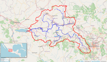
 Map of the Lerma River watershed in Mexico | |
| Location | |
| Country | Mexico |
| Physical characteristics | |
| Source | |
| • location | lagoons near Almoloya del Río, Mexican Plateau |
| • coordinates | 19°09′43″N 99°30′05″W / 19.162041666667°N 99.501452777778°W |
| Mouth | |
• location | Lake Chapala (→Río Grande de Santiago→Pacific Ocean) |
• coordinates | 20°13′N 102°46′W / 20.21°N 102.77°W |
| Length | 750 km (466 mi), without Río Grande de Santiago |
The Lerma River (Spanish: Río Lerma) is Mexico's second longest river.
It is a 750 km-long (470 mi) river in west-central Mexico that begins in Mexican Plateau at an altitude over 3,000 metres (9,843 ft) above sea level, and ends where it empties into Lake Chapala, Mexico's largest lake, near Guadalajara, Jalisco. Lake Chapala is also the starting point of Río Grande de Santiago, which some treat as a continuation of the Lerma River. In combination, the two are often called the Lerma Santiago River (Spanish: Río Lerma Santiago).
The Lerma River is notorious for its pollution, but the water quality has demonstrated considerable improvement in recent years due mostly to government environmental programs and through a vast program of upgrading local sanitation infrastructure.