| Leschenault Bunbury, Western Australia | |||||||||||||||
|---|---|---|---|---|---|---|---|---|---|---|---|---|---|---|---|
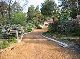
 Typical rural residential lot, on Marine Drive. | |||||||||||||||
 | |||||||||||||||
| Coordinates | 33°14′42″S 115°44′06″E / 33.245°S 115.735°E | ||||||||||||||
| Population | 3,058 (SAL 2021)[1] | ||||||||||||||
| Established | 1990s | ||||||||||||||
| Postcode(s) | 6233 | ||||||||||||||
| Area | 43.5 km2 (16.8 sq mi) | ||||||||||||||
| Location | 16 km (10 mi) from Bunbury | ||||||||||||||
| LGA(s) | Shire of Harvey | ||||||||||||||
| State electorate(s) | Leschenault | ||||||||||||||
| Federal division(s) | Forrest | ||||||||||||||
| |||||||||||||||
Leschenault is an outer suburb of Australind, Western Australia, 6 km to the north-east. Its local government area is the Shire of Harvey. Leschenault is generally considered to be a higher socioeconomic area, with higher than average real estate prices.
- ^ Australian Bureau of Statistics (28 June 2022). "Leschenault (suburb and locality)". Australian Census 2021 QuickStats. Retrieved 28 June 2022.
