You can help expand this article with text translated from the corresponding article in French. (December 2008) Click [show] for important translation instructions.
|
Lescun | |
|---|---|
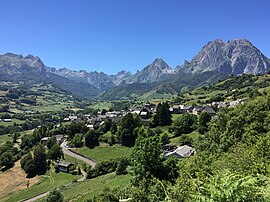
 View of Lescun | |
| Coordinates: 42°56′06″N 0°38′01″W / 42.935°N 0.6336°W | |
| Country | France |
| Region | Nouvelle-Aquitaine |
| Department | Pyrénées-Atlantiques |
| Arrondissement | Oloron-Sainte-Marie |
| Canton | Oloron-Sainte-Marie-1 |
| Government | |
| • Mayor (2020–2026) | Danielle Gay[1] |
| Area 1 | 61 km2 (24 sq mi) |
| Population (2021)[2] | 171 |
| • Density | 2.8/km2 (7.3/sq mi) |
| Time zone | UTC+01:00 (CET) |
| • Summer (DST) | UTC+02:00 (CEST) |
| INSEE/Postal code | 64336 /64490 |
| Elevation | 468–2,504 m (1,535–8,215 ft) (avg. 900 m or 3,000 ft) |
| 1 French Land Register data, which excludes lakes, ponds, glaciers > 1 km2 (0.386 sq mi or 247 acres) and river estuaries. | |
Lescun (French pronunciation: [lɛskœ̃][3]) is a village and a commune in the Pyrénées-Atlantiques department in south-western France.[4]
It is at an elevation of approximately 900 metres (3,000 feet) in a grand cirque.
Lescun is situated on the GR 10 long-distance footpath traversing the Pyrenees. Combined with the dramatic scenery of its mountain backdrop, this makes it a popular focus for hikers and climbers.[5] Several lakes and summits can for example be reached from Lescun, including the lake of Lhurs, the lake of Ansabère, the Billare, the Pic d'Anie, and the Grande Aiguille d'Ansabère.
- ^ "Répertoire national des élus: les maires" (in French). data.gouv.fr, Plateforme ouverte des données publiques françaises. 13 September 2022.
- ^ "Populations légales 2021" (in French). The National Institute of Statistics and Economic Studies. 28 December 2023.
- ^ France 3 Nouvelle-Aquitaine. "Lescun: les recherches s'intensifient pour retrouver le randonneur disparu".
{{cite web}}: CS1 maint: numeric names: authors list (link) - ^ INSEE commune file
- ^ Randonnées à Lescun, Tourisme64


