Levidi
Λεβίδι | |
|---|---|
 | |
| Coordinates: 37°41′N 22°17′E / 37.683°N 22.283°E | |
| Country | Greece |
| Administrative region | Peloponnese |
| Regional unit | Arcadia |
| Municipality | Tripoli |
| Area | |
| • Municipal unit | 312.6 km2 (120.7 sq mi) |
| Elevation | 860 m (2,820 ft) |
| Population (2021)[1] | |
| • Municipal unit | 2,753 |
| • Municipal unit density | 8.8/km2 (23/sq mi) |
| • Community | 920 |
| Time zone | UTC+2 (EET) |
| • Summer (DST) | UTC+3 (EEST) |
| Postal code | 220 02 |
| Area code(s) | 27960 |
| Vehicle registration | TP |
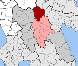
Levidi (Greek: Λεβίδι) is a small town and a former municipality in Arcadia, Peloponnese, Greece. Since the 2011 local government reform it is part of the municipality Tripoli, of which it is a municipal unit.[2] The municipal unit has an area of 312.641 km2.[3] The town is situated on the northeastern slope of the Mainalo mountains, at about 850 m elevation. Levidi is 9 km northwest of Kapsas, 10 km east of Vytina, 12 km southwest of Kandila and 20 km northwest of Tripoli. It is at the junction of the Greek National Road 74 (Tripoli–Pyrgos) and the Greek National Road 66 (Levidi - Nemea).
Levidi was the site of several battles during the Greek War of Independence from the Ottoman Empire, and in ancient times was thought to have been the site of a sanctuary to Artemis Hymnia.
The great Greek-Australian rugby league footballer George Peponis has ancestral ties to this town.
- ^ "Αποτελέσματα Απογραφής Πληθυσμού - Κατοικιών 2021, Μόνιμος Πληθυσμός κατά οικισμό" [Results of the 2021 Population - Housing Census, Permanent population by settlement] (in Greek). Hellenic Statistical Authority. 29 March 2024.
- ^ "ΦΕΚ B 1292/2010, Kallikratis reform municipalities" (in Greek). Government Gazette.
- ^ "Population & housing census 2001 (incl. area and average elevation)" (PDF) (in Greek). National Statistical Service of Greece. Archived (PDF) from the original on 2015-09-21.

