| Lewisham Sydney, New South Wales | |||||||||||||||
|---|---|---|---|---|---|---|---|---|---|---|---|---|---|---|---|
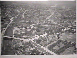
 Aerial photograph of Lewisham in the 1930s showing from left, the railway line, Lewisham Hospital and Petersham Park | |||||||||||||||
 | |||||||||||||||
| Population | 4,060 (2021 census)[1] | ||||||||||||||
| • Density | 6,340/km2 (16,430/sq mi) | ||||||||||||||
| Postcode(s) | 2049 | ||||||||||||||
| Elevation | 22 m (72 ft) | ||||||||||||||
| Area | 0.64 km2 (0.2 sq mi) | ||||||||||||||
| Location | 7 km (4 mi) south-west of Sydney CBD | ||||||||||||||
| LGA(s) | Inner West Council | ||||||||||||||
| State electorate(s) | |||||||||||||||
| Federal division(s) | Grayndler | ||||||||||||||
| |||||||||||||||
Lewisham is a suburb in the Inner West[2] of Sydney, in the state of New South Wales, Australia. Lewisham is located 7 kilometres south-west of the Sydney central business district, in the local government area of Inner West Council.
- ^ Australian Bureau of Statistics (28 June 2022). "Lewisham (NSW)". 2021 Census QuickStats. Retrieved 13 November 2024.
- ^ Australian Suburb Guide: Sydney Inner West Archived 26 December 2012 at the Wayback Machine Retrieved 8 August 2013.