Lexington Hills | |
|---|---|
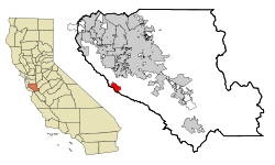
 Location in Santa Clara County and the state of California | |
| Coordinates: 37°9′28″N 121°59′2″W / 37.15778°N 121.98389°W | |
| Country | United States |
| State | California |
| County | Santa Clara |
| Area | |
| • Total | 4.720 sq mi (12.224 km2) |
| • Land | 4.686 sq mi (12.136 km2) |
| • Water | 0.034 sq mi (0.088 km2) 0.72% |
| Elevation | 1,250 ft (381 m) |
| Population (2020) | |
| • Total | 2,492 |
| • Density | 530/sq mi (200/km2) |
| Time zone | UTC-8 (PST) |
| • Summer (DST) | UTC-7 (PDT) |
| ZIP code | 95033 |
| Area codes | 408/669 |
| FIPS code | 06-41282 |
| GNIS feature ID | 1867036 |
Lexington Hills is a census-designated place and an unincorporated area in Santa Clara County, California, United States. The population was 2,492 at the 2020 census. The area is located in the Santa Cruz Mountains, about five miles south of Los Gatos and about 14 miles (23 km) north of Santa Cruz. Lexington Hills is the name assigned by the United States Census Bureau to the area, which actually comprises several small communities, including Redwood Estates, Holy City, Chemeketa Park, and Aldercroft Heights.
- ^ U.S. Census Archived 2012-01-25 at the Wayback Machine
