| Leyte Gulf | |
|---|---|
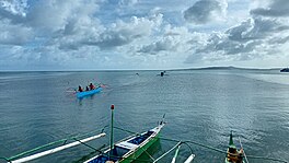
 Motorized outrigger boats over Leyte Gulf in the Eastern Samar town of Guiuan, with Manicani Island in the distance | |
| Location | Eastern Visayas |
| Coordinates | 10°50′00″N 125°25′00″E / 10.8333°N 125.4167°E |
| Type | gulf |
| Etymology | Leyte |
| Part of | Philippine Sea |
| Settlements | |
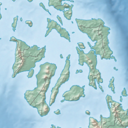
Leyte Gulf, also known simply as the Leyte, is a gulf in the Eastern Visayan region in the Philippines. The bay is part of the Philippine Sea of the Pacific Ocean, and is bounded by two islands; Samar in the north and Leyte in the west. On the south of the bay is Mindanao Island, separated from Leyte by the Surigao Strait.[1][2] Dinagat Island partly encloses the gulf to the southeast, and the small Homonhon Island and Suluan Island, sit astride the eastern entrance to the Gulf. It is approximately 130 km (81 mi) north-south, and 60 km (37 mi) east-west.[2]
Several municipalities are situated on the coast of the gulf: Balangiga, Giporlos, Guiuan, Lawaan, Mercedes, Quinapondan and Salcedo. There are also eleven marine reserves in the gulf region.[3]
Leyte Gulf was also the scene of the Battle of Leyte Gulf, which extends to Surigao Strait during the Battle of Surigao Strait, the largest naval battle of World War II and started the end of Japanese occupation in the Philippines. During World War II the gulf was part of a large US Navy base Leyte-Samar Naval Base.
In 2013, Typhoon Haiyan stirred up a storm surge in Leyte Gulf, resulting in massive loss of lives, agricultural land and property along Leyte's shores.[4]
- ^ Merriam-Webster's Geographic Dictionary, Third Edition, p. 647.
- ^ a b Woodward, C. Vann; Evan Thomas (1997). The Battle for Leyte Gulf: The Incredible Story of World War II's Largest Naval Battle. Skyhorse Publishing Inc. pp. 3–7. ISBN 1-60239-194-7.
- ^ KÜHLMANN, K U (4 April 2002). "Evaluations of marine reserves as basis to develop alternative livelihoods in coastal areas of the Philippines". Aquaculture International. 10 (6): 527–549. doi:10.1023/A:1023955626357. S2CID 34771759.
- ^ Mori, N; Kato, M; Kim, S; Mase, H; Shibutani, Y; Takemi, T; Tsuboki, K; Yasuda, T (28 July 2014). "Local amplification of storm surge by Super Typhoon Haiyan in Leyte Gulf". Geophysical Research Letters. 41 (14): 5106–5113. Bibcode:2014GeoRL..41.5106M. doi:10.1002/2014gl060689. PMC 4373162. PMID 25821268.

