Lhazê County
拉孜县 • ལྷ་རྩེ་རྫོང་། Lhatse, Liza | |
|---|---|
 Old Lhatse Monastery | |
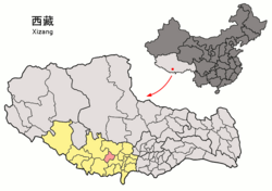
 Location of Lhatse County (red) within Xigazê City (yellow) and Tibet | |
| Coordinates: 29°11′15″N 88°05′34″E / 29.18750°N 88.09278°E | |
| Country | China |
| Autonomous region | Tibet |
| Prefecture-level city | Xigazê |
| County seat | Quxar |
| Area | |
| • Total | 4,488.7 km2 (1,733.1 sq mi) |
| Population (2020)[1] | |
| • Total | 56,355 |
| • Density | 13/km2 (33/sq mi) |
| Time zone | UTC+8 (China Standard) |
| Website | www |
| Lhatse County | |||||||||||
|---|---|---|---|---|---|---|---|---|---|---|---|
| Chinese name | |||||||||||
| Simplified Chinese | 拉孜县 | ||||||||||
| Traditional Chinese | 拉孜縣 | ||||||||||
| |||||||||||
| Tibetan name | |||||||||||
| Tibetan | ལྷ་རྩེ་རྫོང་། | ||||||||||
| |||||||||||
Lhatse County is a county of Xigazê in the Tibet Autonomous Region, China. It was established in 1959, with Lhatse Town as the county seat. In 1968, Quxar Town became the county seat.[2][3]
Lhatse County, has a population of some 50,000 and is about 200 kilometers from Mount Everest (or Chomolungma). It is among the most impoverished counties in China.[4]
- ^ "日喀则市第七次全国人口普查主要数据公报" (in Chinese). Government of Xigazê. 2021-07-20.
- ^ "Lhatse, Lhatse County – Lhatse Trip". China Travel Blogs – Tour-Beijing.com. 2011-09-01. Retrieved 2013-10-20.
- ^ Croddy, E. (2022). China’s Provinces and Populations: A Chronological and Geographical Survey. Springer International Publishing. p. 698. ISBN 978-3-031-09165-0. Retrieved 2024-03-07.
- ^ "Move to hospital deliveries saves mothers, infants in Tibet". Xinhua Writers Bai Xu and Hu Xing. 25 Feb. 2009

