| Lielupe | |
|---|---|
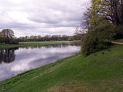
 Lielupe near Mežotne | |
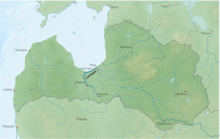
 Course of the Lielupe in Latvia | |
| Location | |
| Country | Latvia, Lithuania |
| Physical characteristics | |
| Source | |
| • location | Bauska, Latvia |
| Mouth | |
• location | Gulf of Riga at Vakarbuļļi |
• coordinates | 57°00′31″N 23°55′59″E / 57.00861°N 23.93306°E |
| Length | 119 kilometres (74 mi) |
| Basin size | 17,600 km2 (6,800 sq mi) (In Latvia: 8,800 km2 or 3,400 sq mi) |
| Discharge | |
| • average | 106 m3/s (3,700 cu ft/s) |
The Lielupe ([ˈli.e.lu.pe] in Latvian literally: Large River, Lithuanian: Lielupė, German: Kurländische Aa) is a river in central Latvia. Its length is 119 km (74 mi) (the length would reach 310 km (190 mi) if the Mēmele River were counted as part of the Lielupe). The surface area of its drainage basin is 17,600 km2 (6,800 sq mi).[1] The average fall of the Lielupe is about (0.1 m/km (0.53 ft/mi)) and its average flow is 106 m3/s (3,700 cu ft/s), although a maximum of 1,380 m3/s (49,000 cu ft/s) has been reached during floods.