This article needs to be updated. (November 2023) |
| Ward of Lime Street | |
|---|---|
 Location within the City | |
Location within Greater London | |
| OS grid reference | TQ332812 |
| Sui generis | |
| Administrative area | Greater London |
| Region | |
| Country | England |
| Sovereign state | United Kingdom |
| Post town | LONDON |
| Postcode district | EC3 |
| Dialling code | 020 |
| Police | City of London |
| Fire | London |
| Ambulance | London |
| UK Parliament | |
| London Assembly | |

Lime Street is one of the 25 ancient wards of the City of London.[1]
It is divided into four precincts; and it is worthy a remark that, though the ward includes parts of several parishes, there is not even a whole street in it. (John Noorthhouck, 1773)
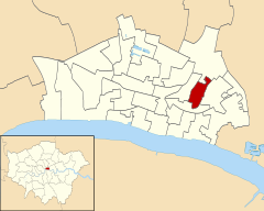
It takes its name from the production of lime in the vicinity during medieval times.[2] It is bounded to the north by Camomile Street, the division with Bishopsgate ward, before travelling due south along its eastern extremity, St Mary Axe (which separates it from Aldgate ward), then south-west to the southernmost point of the ward (where Lime Street itself makes a small peninsula into Langbourn ward), cutting through Leadenhall Market and from there northwards up Gracechurch Street[3] with the ward of Cornhill to the west. Just outside the ward boundary to the east is St Ethelburga's Bishopsgate, bombed by the IRA in 1993 and restored through generous donations,[4] such as that provided by the Lime Street Ward Club.[5]
A well organised[6] ward, it has a long association with the insurance industry,[7] with the specialist market Lloyd's of London based within its boundaries at the Lloyd's building. Three major construction projects – The Pinnacle, the Leadenhall Building and 100 Bishopsgate – are within the boundaries of the ward, and these skyscrapers will dramatically increase the number of workers in the 2010s.
- ^ City of London Police Profile Archived 13 October 2007 at the Wayback Machine
- ^ A Survey of London, Vol. I. Stow, J.: London, A. Fullarton & Co., 1890
- ^ Historical Map
- ^ List of donors Archived 1 September 2007 at the Wayback Machine
- ^ Ward Club Details Archived 6 September 2008 at the Wayback Machine
- ^ Ward Newslatter Archived 27 July 2011 at the Wayback Machine
- ^ The City of London: A History Borer, M. I. C.: New York, D. McKay Co., 1978 ISBN 0-09-461880-1
