This article needs additional citations for verification. (December 2021) |
Limeira | |
|---|---|
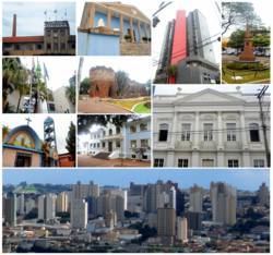
 From left to right, the notable landmarks in Limeira include the Prada Building, the Fraternity Palace, the Commercial Centre Edifice, the revolutionary monument on Toledo Barros plaza, the "Spencer Vampré" City Forum, the Grotto, the Levy Manour, St. Thérèse of Lisieux Church, E.E. Brasil (state high school), and the skyline seen from Jd. Planalto. | |
 Location in São Paulo state | |
| Coordinates: 22°33′54″S 47°24′07″W / 22.56500°S 47.40194°W | |
| Country | Brazil |
| Region | Southeast |
| State | São Paulo |
| Founded | 1826 |
| City Established | April 18, 1863 |
| Government | |
| • Mayor | Mário Botion (2021) (PSD) |
| Area | |
• Total | 581 km2 (224 sq mi) |
| Elevation | 588 m (1,929 ft) |
| Population (2022[1]) | |
• Total | 291,869 |
| • Density | 500/km2 (1,300/sq mi) |
| Time zone | UTC-03:00 (BRT) |
| HDI | 0.775 – high[2] |
| Website | www |
Limeira is a city in the eastern part of the Brazilian state of São Paulo. With a population of approximately 291,869 people (2022 IBGE.) and covering an area of 581 square kilometers, it sits at an elevation of 588 meters.[3] The city is situated 154 kilometers from São Paulo, the capital of the state, and 1011 kilometers from Brasilia, the capital of Brazil. Limeira is conveniently accessible from São Paulo via two highways: Rodovia Anhanguera and Rodovia dos Bandeirantes.
In the past, Limeira was a significant center for coffee cultivation and played a strategic role in the industry. It also earned the nickname "Brazilian orange capital" due to its extensive production of citrus fruits. However, the primary agricultural focus in the city has now shifted to sugar cane cultivation. Limeira has gained international recognition as "Brazil's plated jewelry capital" due to its thriving industry in plated and semi-jewelry. More than 450 companies in Limeira are responsible for half of Brazil's exports in this sector.
Limeira is part of the São Paulo metropolitan complex, which is the largest in the southern hemisphere, with an estimated population of around 30 million people.[4]
- ^ IBGE 2022
- ^ "Archived copy" (PDF). United Nations Development Programme (UNDP). Archived from the original (PDF) on July 8, 2014. Retrieved August 1, 2013.
{{cite web}}: CS1 maint: archived copy as title (link) - ^ Instituto Brasileiro de Geografia e Estatística
- ^ "GOV.BR". Serviços e Informações do Brasil (in Brazilian Portuguese). Retrieved 2023-06-06.


