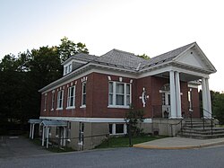
Lincoln, Vermont | |
|---|---|
 | |
 Location in Addison County and the state of Vermont. | |
| Coordinates: 44°5′31″N 72°58′53″W / 44.09194°N 72.98139°W | |
| Country | United States |
| State | Vermont |
| County | Addison |
| Chartered | 1780 |
| Settled | 1790 |
| Organized | 1798 |
| Communities | Lincoln Downingville South Lincoln West Lincoln |
| Area | |
| • Total | 44.6 sq mi (115.5 km2) |
| • Land | 44.4 sq mi (115.0 km2) |
| • Water | 0.2 sq mi (0.5 km2) |
| Elevation | 1,263 ft (385 m) |
| Population (2020) | |
| • Total | 1,323 |
| • Density | 30/sq mi (11.5/km2) |
| Time zone | UTC-5 (Eastern (EST)) |
| • Summer (DST) | UTC-4 (EDT) |
| ZIP code | 05443 |
| Area code | 802 |
| FIPS code | 50-40075[1] |
| GNIS feature ID | 1462135[2] |
| Website | www |
Lincoln is a town in Addison County, Vermont, United States. Lincoln is at the base of Mount Abraham in the Green Mountains. It was settled by Quakers in the late 18th century. The population was 1,323 at the 2020 census.[3] Lincoln is known for its rural beauty and its proximity to two Vermont ski areas, Mad River Glen and Sugarbush.
- ^ "U.S. Census website". United States Census Bureau. Retrieved January 31, 2008.
- ^ "US Board on Geographic Names". United States Geological Survey. October 25, 2007. Retrieved January 31, 2008.
- ^ "Census - Geography Profile: Lincoln town, Addison County, Vermont". United States Census Bureau. Retrieved December 31, 2021.
