Linden Hills | |
|---|---|
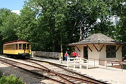
 The Como-Harriet Streetcar Line in Linden Hills | |
| Motto: The Small Town in The City | |
 Location of Linden Hills within the U.S. city of Minneapolis | |
| Country | United States |
| State | Minnesota |
| County | Hennepin |
| City | Minneapolis |
| Community | Southwest |
| City Council Ward | 13 |
| Government | |
| • Council Member | Linea Palmisano |
| Area | |
| • Total | 1.393 sq mi (3.61 km2) |
| Population (2020)[2] | |
| • Total | 7,838 |
| • Density | 5,600/sq mi (2,200/km2) |
| Time zone | UTC-6 (CST) |
| • Summer (DST) | UTC-5 (CDT) |
| ZIP code | 55410, 55416 |
| Area code | 612 |
Linden Hills is a neighborhood in the Southwest community of Minneapolis on a hill overlooking Lake Harriet. It was one of the last areas to be developed in the City of Minneapolis. It is bordered to the north by Bde Maka Ska and West 36th Street, to the east by Lake Harriet and William Berry Parkway, to the south by West 47th Street, and to the west by France Avenue. Southwest High School is located at the southern edge of the neighborhood on West 47th Street between Abbott and Chowen Avenues.
The majority of Linden Hills is in Ward 13,[3] currently represented by Minneapolis City Council member Linea Palmisano. The parts of the Minikahda Club golf course within Linden Hills rest in Ward 7, represented by Katie Cashman.
According to the 2000 U.S. Census, there were 7,370 people in the neighborhood, of whom 94% were white, 1% were black, 0.5% were Native American, 2% were Asian American/Pacific Islander, and 2.5% were other/two or more races.
- ^ "Linden Hills neighborhood in Minneapolis, Minnesota (MN), 55408, 55409, 55410, 55416 detailed profile". City-Data. 2011. Retrieved 2013-11-19.
- ^ "Linden Hills neighborhood data". Minnesota Compass. Retrieved 2023-02-19.
- ^ "Find My Ward". City of Minneapolis. Retrieved 19 April 2024.