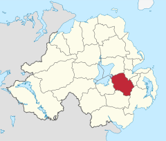
| Lisburn City Council | |
|---|---|
 | |
| Area | 447 km2 (173 sq mi) Ranked 16th of 26 |
| District HQ | Lisburn |
| Catholic | 36.5% |
| Protestant | 55.9% |
| Country | Northern Ireland |
| Sovereign state | United Kingdom |
| Website | www |
Lisburn City Council was the local authority for an area partly in County Antrim and partly in County Down in Northern Ireland. As of May 2015 it was merged with Castlereagh Borough Council as part of the reform of local government in Northern Ireland to become Lisburn and Castlereagh City Council.
Created in 1974, the council was the second largest in the Belfast Metropolitan Area. Council headquarters were in the city of Lisburn. It was the second-largest council area in Northern Ireland with over 120,000 people and an area of 174 square miles (450 km2) of southwest Antrim and northwest Down. The council area included Glenavy and Dundrod in the north, Dromara and Hillsborough in the south, Moira and Aghalee in the west, and Drumbo in the east.
The council area consisted of five electoral areas: Downshire, Dunmurry Cross, Killultagh, Lisburn Town North and Lisburn Town South. It had 30 councillors, last elected in 2011. The final composition was: 14 Democratic Unionist Party (DUP), 5 Ulster Unionist Party (UUP), 5 Sinn Féin, 3 Alliance Party and 3 Social Democratic and Labour Party (SDLP).
For elections to the Westminster Parliament, the council area was split between the Lagan Valley constituency, Belfast West and South Antrim constituencies.[1]
The first elections for the new council took place in May 2014.[2]
- ^ "Archived copy" (PDF). Archived from the original (PDF) on 28 February 2008. Retrieved 8 March 2008.
{{cite web}}: CS1 maint: archived copy as title (link) - ^ "Your City Council". Lisburn City Council. Archived from the original on 26 August 2014. Retrieved 24 August 2014.