 Standard route marker for county routes in Hamilton County | |
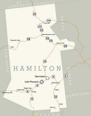
 Hamilton County's road system, which mainly consists of state touring routes | |
| Highway names | |
|---|---|
| Interstates | Interstate X (I-X) |
| State | New York State Route X (NY X) |
| County: | County Route X (CR X) |
| System links | |
The highway system of Hamilton County, New York, comprises 474.5 miles (763.6 km) of roads maintained by the New York State Department of Transportation (NYSDOT), the county, and its towns and villages. NYSDOT maintains five state touring routes in Hamilton County, which account for a combined 178.7 miles (287.6 km) of New York's state highway mileage.[1] These five routes are supplemented by Hamilton County's county route system, which comprises 25 roads of varying length and importance. The 94.5-mile (152.1 km) system, maintained by the Hamilton County Department of Public Works, connects the state routes to a number of small hamlets and other points of interest.[2]
Hamilton County's five state routes are spread throughout the county,[3] which is the least populated in the state of New York.[4] The routes are NY 8, NY 10, NY 28, NY 28N, and NY 30. The longest is NY 30, which extends for 83.72 miles (134.73 km) on a north–south alignment from the Fulton County line to the Franklin County line.[2] The five state highways traverse highly rural sections of Adirondack Park; in fact, the only village along any of these roads is Speculator, located at the western junction of NY 8 and NY 30. NY 10 and NY 28 were assigned in 1924,[5] while the others were assigned in 1930.[6] NY 365 once passed through the county; however, it was truncated southwestward to end in Oneida County in the late 1950s.[7][8] Additionally, NY 10 extended north along modern NY 30 to the Canada–US border until c. 1960, when it was replaced with NY 30 north of Speculator.[8][9] Since the truncation of NY 10, there have not been any substantial changes to roads in Hamilton County.[10]
- ^ Cite error: The named reference
nysdot-mileagewas invoked but never defined (see the help page). - ^ a b Cite error: The named reference
inv-hamiltonwas invoked but never defined (see the help page). - ^ Hamilton County, New York (Map). Google Maps. 2008. Retrieved September 13, 2008.
- ^ "Hamilton County, New York". U.S. Census Bureau. 2000. Archived from the original on June 7, 2011. Retrieved September 13, 2008.
- ^ "New York's Main Highways Designated by Numbers". The New York Times. December 21, 1924. p. XX9.
- ^ Dickinson, Leon A. (January 12, 1930). "New Signs for State Highways". The New York Times. p. 136.
- ^ New York with Special Maps of Putnam–Rockland–Westchester Counties and Finger Lakes Region (Map) (1958 ed.). Cartography by General Drafting. Esso. 1958.
- ^ a b New York and New Jersey Tourgide Map (Map). Cartography by Rand McNally and Company. Gulf Oil Company. 1960.
- ^ Ontario (Map). Cartography by General Drafting. Imperial Oil. 1959. Archived from the original on August 23, 2008. Retrieved December 17, 2007.
- ^ Cite error: The named reference
2008mapwas invoked but never defined (see the help page).