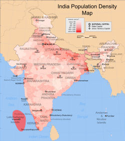
India is a union of twenty-eight states and eight union territories.[1] As of 2011, with an estimated population of 1.210 billion, India occupies 2.4 percent of the world's land surface area but is home to 17.5 percent of the world's population.[2] The Indo-Gangetic plains are among the most densely populated areas of the world. The eastern and western coastal regions of Deccan traps are also densely populated regions of India. The Thar desert in western Rajasthan is one of the most densely populated deserts in the world. The northern and north-eastern states along the Himalayas contain cold arid deserts with fertile valleys. These states have less population density due to indomitable physical barriers.[3]
- ^ "States and union territories". Government of India (2001). Census of India. Retrieved 2007-09-07.
- ^ "Area and Population". Government of India (2011). Census of India. Retrieved 2011-04-07.
- ^ "India - General Profile, Land Use Classification and Land Use Pattern" (PDF). National Informatics Centre (NIC). Ministry of Environment & Forests (MoEF). Archived from the original (PDF) on 2006-05-14. Retrieved 2008-12-12.