Lista Municipality
Lista herred | |
|---|---|
| Vanse herred (historic name) | |
 | |
 Vest-Agder within Norway | |
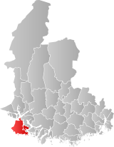
 Lista within Vest-Agder | |
| Coordinates: 58°05′43″N 06°47′37″E / 58.09528°N 6.79361°E | |
| Country | Norway |
| County | Vest-Agder |
| District | Lister |
| Established | 1 Jan 1838 |
| • Created as | Formannskapsdistrikt |
| Disestablished | 1 Jan 1965 |
| • Succeeded by | Farsund Municipality |
| Administrative centre | Vanse |
| Area (upon dissolution) | |
| • Total | 193 km2 (75 sq mi) |
| Population (1965) | |
| • Total | 4,544 |
| • Density | 24/km2 (61/sq mi) |
| Demonyms | Listelending Listring[1] |
| Time zone | UTC+01:00 (CET) |
| • Summer (DST) | UTC+02:00 (CEST) |
| ISO 3166 code | NO-1041[2] |
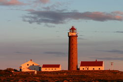
Lista is a former municipality located in the old Vest-Agder county in Norway. The 193-square-kilometre (75 sq mi) municipality existed from 1838 until its dissolution in 1965. The administrative centre was the village of Vanse where Vanse Church is located. Lista municipality was historically known as the municipality of Vanse until 1911. The former municipality's land is now located in the present-day municipality of Farsund in Agder county.
Farsund Airport, Lista is located here, but it has not had any regularly scheduled commercial flights since 1999; however, there are discussions to use it as a base for offshore operations. Lista is located on a large peninsula along the Listafjorden and is home to the villages of Vestbygd and Vanse and the town of Farsund.
- ^ "Navn på steder og personer: Innbyggjarnamn" (in Norwegian). Språkrådet.
- ^ Bolstad, Erik; Thorsnæs, Geir, eds. (26 January 2023). "Kommunenummer". Store norske leksikon (in Norwegian). Kunnskapsforlaget.