| Little Avon River | |
|---|---|
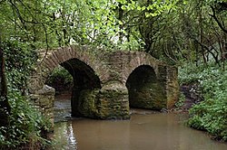
 Sturt Bridge near Wickwar, a packhorse bridge on the Little Avon River | |
| Location | |
| Country | United Kingdom |
| Parts | England |
| Region | South West |
| Administrative areas | Gloucestershire, South Gloucestershire |
| Physical characteristics | |
| Source | |
| • location | Horton, Gloucestershire, England |
| • coordinates | 51°33′30″N 2°21′12″W / 51.558373°N 2.353447°W |
| Mouth | Berkeley Pill |
• location | Severn Estuary, United Kingdom |
• coordinates | 51°41′58″N 2°29′18″W / 51.69952°N 2.488404°W |
 | |
The Little Avon River is a small river partly in southern Gloucestershire and partly in South Gloucestershire. For much of its length it forms the boundary between the county of Gloucestershire and the unitary authority of South Gloucestershire. It rises to the east of Wickwar, near Horton, passes near Charfield, Stone and Berkeley, and enters the River Severn via Berkeley Pill. It was formerly navigable up to moorings at Berkeley, but a flood-prevention scheme, built in the 1960s, now prevents navigation more than a few hundred metres upstream.
