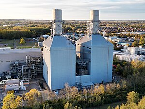
| Little Barford Power Station | |
|---|---|
 Little Barford power station in 2023 | |
 | |
| Official name | Little Barford power station |
| Country | England |
| Location | Bedfordshire |
| Coordinates | 52°12′16″N 0°16′8″W / 52.20444°N 0.26889°W |
| Status | A & B decommissioned and demolished, C: operational |
| Commission date | A: 1941, B: 1959, CCGT: 1994 |
| Decommission date | A: 1981 B: 1984 |
| Owners | British Electricity Authority (1948–1955) Central Electricity Authority (1955–1957) Central Electricity Generating Board (1958–1990) |
| Operator | RWE Generation UK |
| Thermal power station | |
| Primary fuel | A & B Coal, CCGT Natural gas |
| Tertiary fuel | Fuel oil |
| Chimneys | A & B 3 |
| Cooling towers | A & B 2 |
| Cooling source | A & B river water + cooling towers, river water + hybrid cooling towers |
| Combined cycle? | Yes |
| Power generation | |
| Units operational | CCGT 2 total 727 MW |
| Make and model | General Electric Frame 9F gas turbines |
| Units decommissioned | A & B all decommissioned |
| Nameplate capacity | CCGT 727 MWe |
| Annual net output | A & B see graphs in text |
| External links | |
| Commons | Related media on Commons |
grid reference TL185577 | |
Little Barford Power Station is a gas-fired power station just north of the village of Little Barford in Bedfordshire, England. It lies just south of the A428 St Neots bypass and east of the Wyboston Leisure Park. The River Great Ouse runs alongside. It was formerly the site of two coal-fired power stations, now demolished. The station is operated by RWE.
The net capacity of 727 MW is sufficient to supply over half a million households.[1]
- ^ "Little Barford power plant". RWE. Retrieved 3 November 2019.