Māori: Te Hauturu-o-Toi Nickname: Hauturu | |
|---|---|
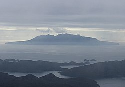
 View of Little Barrier Island from Great Barrier Island | |
| Geography | |
| Location | Hauraki Gulf, Auckland Region |
| Coordinates | 36°11′57″S 175°04′53″E / 36.1991°S 175.0814°E |
| Area | 28.17 km2 (10.88 sq mi) |
| Length | 7.5 km (4.66 mi) |
| Width | 5.5 km (3.42 mi) |
| Highest elevation | 722 m (2369 ft) |
| Highest point | Mount Hauturu |
| Administration | |
| Demographics | |
| Population | No permanent inhabitants |
| Additional information | |
| Wildlife sanctuary | |
Little Barrier Island, or Hauturu in Māori[1] (the official Māori title is Te Hauturu-o-Toi[2]), lies off the northeastern coast of New Zealand's North Island. Located 80 kilometres (50 mi) to the north of Auckland, the island is separated from the mainland to the west by the Jellicoe Channel, and from the larger Great Barrier Island to the east by the Cradock Channel. The two aptly named islands shelter the Hauraki Gulf from many of the storms of the Pacific Ocean.

Settled by the Māori between 1350 and 1650, the island was occupied by them until the New Zealand government declared the island a wildlife sanctuary in 1897. Since the island came under control of the government, it has been under limited access, with only a few rangers living on the island. In the Māori language, the name of the island name means "the resting place of lingering breezes".[1] Along with its larger neighbour Great Barrier, it was given its English name by Captain James Cook in 1769.[3]
The island is a nature sanctuary which has been described by the MBIE as "the most intact [native] ecosystem in New Zealand".[4] However, several invasive species were introduced by both Maori and European settlers, including cats, which were destructive to local small bird and reptile species until they were eradicated between July 1977 and June 1980 in what was possibly New Zealand's costliest pest control programme. This was followed by a rat eradication programme from 2004. A cost benefit analysis has been published.[5]: 558–567
- ^ a b "The Hauraki Gulf Marine Park, Part 2". Inset to The New Zealand Herald. 3 March 2010. p. 15.
- ^ "Islands and bays renamed in Maori". stuff.co.nz. 2011. Retrieved 7 June 2011.
Te Hauturu-o-Toi
- ^ "Chronology of events" (PDF). Retrieved 13 September 2012.
- ^ "New Zealand Energy Quarterly, March 2010" (PDF). 16 June 2010. Retrieved 8 July 2010.
- ^ Griffiths, R.; Bell, E.; Campbell, J.; Cassey, P.; Ewen, J.G.; Green, C.; Joyce, L.; Rayner, M.; Toy, R.; Towns, D.; Wade, L.; Walle, R.; Veitch, C.R. (2019). "Costs and benefits for biodiversity following rat and cat eradication on Te Hauturu-o-Toi/Little Barrier Island. Island invasives: scaling up to meet the challenge". In Veitch, C.R.; Clout, M.N.; Martin, A.R.; Russell, J.C.; West, C.J. (eds.). Island invasives: scaling up to meet the challenge international conference on island invasives. 2017 Proceedings of the Occasional Paper of the IUCN Species Survival Commission N 62. Vol. 62. pp. 1–733. ISBN 978-2-8317-1961-0.
