| Little Minnesota River | |
|---|---|
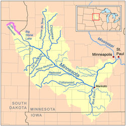
 Map of the Minnesota River watershed with the Little Minnesota River highlighted | |
| Location | |
| Country | United States |
| States | South Dakota, Minnesota |
| Counties | Roberts and Marshall Counties, Traverse and Big Stone Counties Minnesota |
| Physical characteristics | |
| Source | |
| • location | near Veblen, South Dakota, Easter Township, South Dakota |
| • coordinates | 45°41′20″N 97°00′12″W / 45.689022°N 97.003452°W |
| Mouth | |
• location | Big Stone Lake |
• coordinates | 45°33′14″N 96°47′43″W / 45.55390°N 96.79540°W |
| Length | 71.4 mi-long (114.9 km) |
| Basin features | |
| Tributaries | |
| • left | Standfast Creek, Jorgenson River |
The Little Minnesota River is a 71.4-mile-long (114.9 km)[1] headwaters tributary of the Minnesota River in northeastern South Dakota and west-central Minnesota in the United States.[2] Via the Minnesota River, it is part of the Mississippi River watershed.[3]
- ^ U.S. Geological Survey. National Hydrography Dataset high-resolution flowline data. The National Map Archived 2012-03-29 at the Wayback Machine, accessed October 5, 2012
- ^ Federal Writers' Project (1940). South Dakota place-names, v.3. University of South Dakota. p. 4. Archived from the original on 2020-07-20.
- ^ U.S. Geological Survey Geographic Names Information System: Little Minnesota River
