| Little River | |
|---|---|
 The lower course of the Little River features swamps, Bald Cypress forests, and American alligators at the northwestern limit of their range. | |
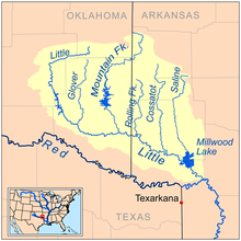
 Map of the Little River watershed | |
| Native name | Iskitinifalaya (Choctaw) |
| Location | |
| Country | United States |
| States | Oklahoma, Arkansas |
| Physical characteristics | |
| Source | |
| • elevation | 70 m (230 ft) |
| Mouth | Red River |
| Length | 350 km (220 mi) |
| Basin size | 10,889 km2 (4,204 sq mi) |
| Discharge | |
| • location | Horatio, Arkansas |
| • average | 4,084 cu/ft. per sec.[1] |
| Basin features | |
| River system | Red River (Mississippi watershed) |
The Little River is a tributary of the Red River, with a total length of 217 miles (349 km), 130 miles (210 km) within the Choctaw Indian Reservation in southeastern Oklahoma and 87 miles (140 km) in southwestern Arkansas[2] in the United States. Via the Red, it is part of the watershed of the Mississippi River. Six large reservoirs impound the Little River and its tributaries. The drainage basin of the river totals 4,204 square miles (10,890 km2), 2,204 square miles (5,710 km2) in Oklahoma and 2,036 square miles (5,270 km2) in Arkansas. The Little River and its upper tributaries are popular for recreational canoeing and kayaking.
- ^ "USGS Current Conditions for USGS 07340000 Little River near Horatio, AR".
- ^ "Lower LIttle River Watershed" http://arkansaswater.org/materials/12-%20Lower%20Little%20River%2004-20-2006.pdf, accessed 29 Mar 2013