| Little Rock Creek | |
|---|---|
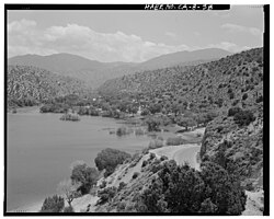
 View to south over reservoir into Little Rock Creek Watershed | |
 | |
| Location | |
| Country | United States |
| State | California |
| Region | Los Angeles County |
| Cities | Littlerock, Palmdale |
| Physical characteristics | |
| Source | Mount Williamson |
| • location | San Gabriel Mountains |
| • coordinates | 34°22′16″N 117°51′35″W / 34.37111°N 117.85972°W[1] |
| • elevation | 8,000 ft (2,400 m)[2] |
| Mouth | Little Rock Reservoir |
• coordinates | 34°28′09″N 118°01′11″W / 34.46917°N 118.01972°W[1] |
• elevation | 3,268 ft (996 m)[1] |
| Basin features | |
| Tributaries | |
| • left | South Fork Little Rock Creek, Santiago Canyon Creek |
Little Rock Creek is a 16.7-mile (26.9 km) northwestward-flowing stream in the San Gabriel Mountains and Mojave Desert, within northern Los Angeles County, California.
Its headwaters are in the Angeles National Forest, just west of Mount Williamson peak.[1] Downstream the creek enters Little Rock Reservoir, impounded by Little Rock Dam. After released there it flows through Little Rock Wash into the Antelope Valley of the western Mojave Desert.[1]
The California Office of Environmental Health Hazard Assessment has issued a safe eating advisory for any fish caught in Little Rock Reservoir due to elevated levels of mercury and PCBs.[3]
- ^ a b c d e "Little Rock Creek". Geographic Names Information System. United States Geological Survey, United States Department of the Interior.
- ^ U.S. Geological Survey. National Hydrography Dataset high-resolution flowline data. The National Map Archived 2012-03-29 at the Wayback Machine, accessed November 30, 2014
- ^ Admin, OEHHA (2014-03-24). "Little Rock Reservoir". OEHHA. Retrieved 2018-11-08.