Liverpool, Texas | |
|---|---|
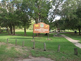
 Albert Finkle County Park in Liverpool | |
 Location of Liverpool, Texas | |
 | |
| Coordinates: 29°17′57″N 95°16′39″W / 29.29917°N 95.27750°W | |
| Country | United States |
| State | Texas |
| County | Brazoria |
| Area | |
| • Total | 1.09 sq mi (2.83 km2) |
| • Land | 1.09 sq mi (2.83 km2) |
| • Water | 0.00 sq mi (0.00 km2) |
| Elevation | 20 ft (6 m) |
| Population (2020) | |
| • Total | 475 |
| • Density | 440/sq mi (170/km2) |
| Time zone | UTC-6 (Central (CST)) |
| • Summer (DST) | UTC-5 (CDT) |
| ZIP code | 77577 |
| Area code(s) | 281, 832 |
| FIPS code | 48-43120[2] |
| GNIS feature ID | 1361569[3] |
| Website | cityofliverpooltexas |
Liverpool is a city in Brazoria County, Texas, United States, named after the city of Liverpool in England. It is located along the Union Pacific Railroad and County Road 171, northeast of Angleton and south of Alvin. The population was 475 at the 2020 census.
- ^ "2019 U.S. Gazetteer Files". United States Census Bureau. Retrieved August 7, 2020.
- ^ "U.S. Census website". United States Census Bureau. Retrieved January 31, 2008.
- ^ "US Board on Geographic Names". United States Geological Survey. October 25, 2007. Retrieved January 31, 2008.