Livingston, Montana | |
|---|---|
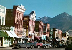
 Downtown Livingston (2005) | |
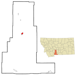
 Location within Park County and Montana | |
| Coordinates: 45°39′32″N 110°33′49″W / 45.65889°N 110.56361°W[1] | |
| Country | United States |
| State | Montana |
| County | Park |
| Area | |
• Total | 6.04 sq mi (15.63 km2) |
| • Land | 5.98 sq mi (15.49 km2) |
| • Water | 0.06 sq mi (0.15 km2) |
| Elevation | 4,502 ft (1,372 m) |
| Population (2020) | |
• Total | 8,040 |
| • Density | 1,344.71/sq mi (519.16/km2) |
| Time zone | UTC-7 (Mountain (MST)) |
| • Summer (DST) | UTC-6 (MDT) |
| ZIP code | 59047 |
| Area code | 406 |
| FIPS code | 30-43975 [1] |
| GNIS ID | 773511 [1] |
| Website | livingstonmontana.org |
Livingston, occasionally referred to as L-Town by locals, is a city and county seat of Park County, Montana, United States.[1] It is in southwestern Montana, on the Yellowstone River, north of Yellowstone National Park. As of the 2020 census, the population of the city was 8,040.[3]
- ^ a b c d e "Livingston, Montana", Geographic Names Information System, United States Geological Survey, United States Department of the Interior
- ^ "ArcGIS REST Services Directory". United States Census Bureau. Retrieved September 5, 2022.
- ^ "Profile of Livingston, Montana in 2020". United States Census Bureau. Archived from the original on June 26, 2022. Retrieved June 26, 2022.