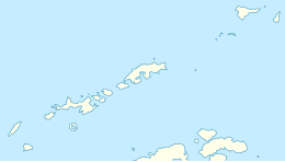
 Map of Livingston Island | |
| Geography | |
|---|---|
| Location | Antarctica |
| Coordinates | 62°36′S 60°30′W / 62.600°S 60.500°W |
| Archipelago | South Shetland Islands |
| Area | 798 km2 (308 sq mi) |
| Length | 73 km (45.4 mi) |
| Width | 36 km (22.4 mi) |
| Highest elevation | 1,700.2 m (5578.1 ft) |
| Highest point | Mt Friesland |
| Administration | |
| Administered under the Antarctic Treaty System | |
| Demographics | |
| Population | ca. 80 (summer only) |
| Pop. density | 0.1/km2 (0.3/sq mi) |
| Ethnic groups | Spaniards, Bulgarians, Chileans, Americans and Argentines |
| Highest elevation entry refers to the maximum value recorded, which is subject to possible variation as the island's highest summits are ice-covered. | |
Livingston Island (Russian name Smolensk,[1][a] 62°36′S 60°30′W / 62.600°S 60.500°W) is an Antarctic island in the Southern Ocean, part of the South Shetlands Archipelago, a group of Antarctic islands north of the Antarctic Peninsula. It was the first land discovered south of 60° south latitude in 1819, a historic event that marked the end of a centuries-long pursuit of the mythical Terra Australis Incognita and the beginning of the exploration and utilization of real Antarctica. The name Livingston, although of unknown derivation, has been well established in international usage since the early 1820s.
Cite error: There are <ref group=lower-alpha> tags or {{efn}} templates on this page, but the references will not show without a {{reflist|group=lower-alpha}} template or {{notelist}} template (see the help page).

